Wednesday, August 28, 2019

Playing Catch-up

   It has been a quite a while (March?!!) since I have written about bicycle projects, as I was
trying to clear out all of the finished bicycles I had in stock before starting anything new. I had been doing plenty of rides in the meantime (hope you were reading), and by the time Sue and I were packed for our trip, everything, except the framesets-to-be-bicycles, had been sold!
   Now it's time to get busy back in the shop. There has been quite a bit of progress during the past couple of weeks we have been home. A nice pile of parts had been on hold at the post office, and I had a decent amount of work just unpackaging everything.

   Just before we left for Michigan, a new friend and fellow Lehigh Valley native named James had dropped off a 1987 Schwinn Prelude that he wanted to pass onto his son. This bicycle was produced before Schwinn went the Walmart, off-the-shelf route of cheaply made and outfitted bicycles. James’ Prelude had Columbus Tenax tubing, which may not be at the level of SLX or even Cromor tubes, but it is quality stuff, certainly at the price point at which you’ll find a Schwinn!
   The bike was set up with a mix of new and old Shimano components, including downtube shifters, and a Sakae crankset. James’ wish was to convert the bike to a more modern Campagnolo group with Ergo shifters, and I had a nice Chorus 8-speed group on my shelf, which fit the bill perfectly. The bike had 126mm rear spacing, so a bit of cold setting was needed in order to fit set of freehub-equipped Campy Melbourne 56 wheels.


   James stopped by the other day to pick up the Prelude and brought along his Schwinn Super Sport (also of the quality era) to switch out some parts. It wasn’t quite “Bicycle University”, as he had a good base of knowledge compared to some of my previous students/guests, but he tried his hand at some of the work and provided some great conversation during the afternoon of tinkering.

   Before our vacation, I had also squeezed in a trip to North Jersey to pick up a donor bicycle for the Casati Fibra build. Lately I’m finding the donor route to be the more affordable way to go for higher-end parts, especially when purchasing through craigslist. EBay unfortunately started charging sales tax on Pennsylvania buyers, and when picking up bicycles and component groups for a few hundred dollars, that extra 6-8% on the bill is not fun at all.
   I met a guy named Anthony, who was a bit of a collector of everything, especially automobiles and related parts. He had picked up a solid Univega frameset made of Columbus Thron tubing and put some really nice Campagnolo Record parts on it – frankly, the desirability of the frame brand didn’t match that of the excellent parts, and he had no takers.
   This was perfect situation for me, as I knew the value of the components alone, and with the willingness to disassemble the bike, I would stand to make a little money back from selling the parts I wouldn’t need. The frame is in really nice shape for a 2001 model, and someone should pick it up as a base for an inexpensive project bike of their own.

   The Olmo Sportsman should be wrapped up in the next few days, as I’ve finally collected all the needed parts, including a missing cable guide that I had overlooked – or maybe that’s the wrong term, since it is under the bottom bracket, which is why I didn’t notice. I was all set to run the cables to the derailleurs, only to be frustrated by the delay in ordering the part. It will be in the next blog entry FOR SURE!

   A new project I’m looking forward to is a 1990 Bottechia 989 Comp, painted for the Malvor-Sidi-Bottecchia pro team of that season. The frame is similar to another Bottecchia I had built up a few years ago, in that it has all the sponsor logos on the stays, so that I have a guide to which components to use. In this case, it will be Shimano Dura-Ace, ITM, Selle Italia and Michelin.

   Another endeavor is the assembly of a mid-1990s Patelli bicycle that was shipped to me from a gentleman who lives just down the street from the company’s factory in Bologna. In fact, he shipped me a set of decals purchased at the company store, including the bag (see blog intro photo) in which he brought the decals home!


   The decals are of the water-slide variety (like you would apply to a plastic model) and would require a clear coat over top for protection. I really didn’t want to be bothered with that, so I purchased a modern vinyl set instead. The frame is shiny, unpainted Columbus Thronic tubing, which I assume is the same as the Thron tubing with which am so familiar – only guessing here, but the word “custom” on the label  might provide a clue towards what difference there might be, plus the fact that this Patelli frame has tubes with welded joints that don’t have lugs.
   The bicycle came with Campagnolo gruppo (Athena components/ Gamma wheels) and a set of ITM bars and stem. I’ve purchased a Cinelli cockpit to swap in and will match up the ITM with the Bottecchia 989 instead. While awaiting delivery of the parts, I applied the Patelli decals – note the original Gomarasca bicycle shop sticker, as the bicycle was originally purchased in the Cassina de Pecchi section of Milan!


   Finally, and this one was a quick turnaround after a long wait for shipment from a connection in the Netherlands, I completed a small refurbish job on a 1988 Concorde Columbo, painted in the scheme of the Dutch PDM pro team. This bicycle particularly appealed to me, since the team was around in my formative years as a pro cycling fan, I remember stars like Sean Kelly, Greg Lemond, Pedro Delgado, Adri van der Poel, Steven Rooks and Eric Breukink all riding at some point for the squad that lasted from 1986-1992.
   The core of the components on the bike are Shimano 105, with a stylish 3T cockpit and some excellent Wolber “hoops” guiding the machine through the curves. I just needed to give the bicycle a good cleaning, replace the worn cables and housing and added a classic Selle Italia Turbo saddle.


   I am in the process of re-stocking, so there are a few more new goodies being shipped to Royersford, which I’ll tell you all about in the upcoming weeks.


Friday, August 16, 2019

Ontario, Canada and Michigan's Upper Peninsula - Wrap-up

   We had really been lucking out during this whole trip with the weather – not only had it been cool and dry most days, but we also had very little rain. When we did have showers, they only lasted for a brief time, and usually after we had done whatever activity that was planned for the day.
   Unfortunately, the atmosphere around Buffalo was a little unsettled. Although it was still relatively dry and cool, there were thunderstorms lurking about nearly every day, a situation I’m sure was influenced by the Great Lakes moisture.

   Sue and I took umbrellas with us when we went on a downtown walk on Wednesday afternoon. We parked near the Old Post Office, built in 1901 and now home to SUNY Erie Community College. The Gothic Revival structure was actually designed by the Office of the Supervising Architect, an agency of the United States Treasury Department that planned federal government buildings from 1852 to 1939. “What a place to go to community college courses!” I said to Sue.


   Architecture in Buffalo, especially the buildings constructed between the Civil War and the Great Depression, is said to have created a new, distinctly American form and to have influenced design throughout the world. Within a couple blocks we could see the gold-leaf dome of the Buffalo Savings Bank, a Beaux-Arts-style structure from 1901, designed by Buffalo architect E.B. Green...


...and the stunning terracotta decoration on the façade of the Prudential (Guaranty) Building, Louis Sullivan’s extraordinary 1896 design.


   Our main destination was the Ellicott Square Building, named for Joseph Ellicott, on whose original estate this building was erected. Ellicott was an agent of the Holland Land Company, and in 1803, he laid out the village of New Amsterdam, now the city of Buffalo. His heirs commissioned Daniel Burnham to design what became at that time the world’s largest office building.


   Daniel Burnham is a personal favorite of mine, as he designed the spectacular Pennsylvania Station in Pittsburgh. Folks from the Philadelphia area will be familiar with his Wanamaker Department Store (now Macy’s); most people would easily recognize the Flatiron Building in NYC or Union Station in Washington, D.C., among many of his marvelous structures across the country. His architectural mantra was "make no little plans, they have no magic to stir men’s blood; think big.”
   The Ellicott Square Building was completed 1896 in the Italian Renaissance style, using granite, iron, and terra cotta with a veneer of pearl-gray brick. The grand interior courtyard contains a marble mosaic floor, made up of 23 million pieces of marble imported from Italy, depicting sun symbols from civilizations around the world.


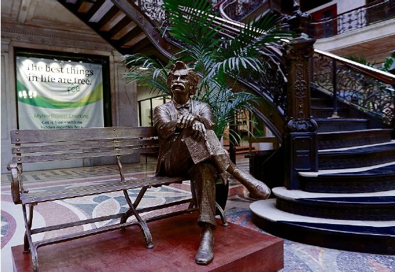
   In one corner of the courtyard is a wonderful bronze statue of Mark Twain on a bench. The great author lived in the city 1869-1871, when he was the co-editor of The Buffalo Express, which had its newspaper office on the eventual site of the Ellicott Square Building.
Image result for mark twain statue ellicott building

   We concluded our little stroll along Main Street, following the Metro Rail route, down the “sports corridor” from Sahlen Field, the home of the Bisons, the Toronto Blue Jays AAA baseball affiliate, to Key Bank Center, the home of the National Hockey League’s Sabres.
   After dinner, Sue and I went to see Shakespeare in Delaware Park, one of the largest free outdoor Shakespeare festivals in the country. Now a 44-year tradition, the organization usually puts on two productions, each for half of the summer months, Tuesday-Sunday evenings. We saw Love’s Labour’s Lost, a wonderfully funny play done very well by the cast!


   There were strong thunderstorms forecast for later Thursday afternoon, so we drove out early to Tonawanda so that we could get in (at least) a ride on the Erie Canalway Trail out to Lockport and back before the bad weather started. The first couple miles of the trail were through parks that lined the canal, and there were a few people out in their kayaks enjoying the cool morning air.
   I had scouted out our route pretty well the night before, using the Rails-To-Trails website Trail Link map in combination with GoogleMaps street view, as I knew that there were some unconnected segments of the canal trail that required some on-road “detours”. The first one came fairly early when Tonawanda Creek Road veered to the right to cut off a big bend in the canal where a cemetery was located.
   It’s a good thing I did check the route, because there were a couple points later were the trail ended with a sign simply telling you “Trail Ends” with no direction. Granted, you could generally just follow the canal and pick up the trail again, but there was a confusing area where the Tonawanda Creek and Erie Canal form a wye, and it might not be so obvious to the geographically challenged which branch of water you should be following.
   Even with my double-checking, I made a small error by taking the first of two bridges towards the hamlet of Pendleton Center, instead of the town of Pendleton, but we had an idea that we were moving at the wrong compass heading and corrected our route. I stopped to ask someone, just to make sure we were going the right way, and was amused that she was used to giving directions to cyclists in the area because of the “less-than-perfect markings”.
   The width of the path narrowed greatly once out of the park areas, but it was all paved, though the quality of asphalt varied. When we pedaled onto a very new section of trail that was cleared of the trees that are pretty much a constant presence along the canal, we noticed the sky becoming really dark to the north. We were hoping it was moving off, based on what the weatherman had predicted.
   We reached Lockport in time to see a motorboat pull out of lock 35 and just before hearing the first rumble of thunder.


   Locks 34 and 35 bypassed the old Flight of Five locks that carried boats a change in 60 feet of elevation at the Niagara Escarpment. The five locks are currently undergoing a restoration project that will allow tourists to ride a replica canal boat through the Lockport landmark.


   Sue and I took refuge in the local library for an hour or so, until the storm blew over. The temperature had dropped about ten degrees, and it wasn’t that warm in the first place, so we were dreading a cold, wet ride back to Tonawanda. Fortunately, things cleared up nicely, and but for a couple miles of splashing through puddles, the wind and sun helped to dry out our riding surfaces fairly quickly.
   My original plan was to do a bit of exploring and ride back to Buffalo on my own, and I was glad the weather was giving me a break, though the wind was kicking up and waves of clouds had me thinking I shouldn’t dally! I first rode into North Tonawanda to find a couple more train stations and immediately noticed the corner light posts had carousel horses attached to them.
   On Thompson Street is the Herschel Carrousel Factory and Museum, which sits nicely along the city’s Heritage Trail that runs diagonally across a few blocks on the former right-of-way of the New York Central Railroad. The museum had a few kiddie rides operating outside for the summer.


   I did a sharp turn to head down the short trail and was surprised to find a boarded-up interlocking tower. This structure would have housed a towerman who controlled movements between the two intersecting railroads (in this case the NYC and Erie) with signals and perhaps operated a switch or two in the area, using large, powerful levers. Interlocking towers used to be all over the country, until the operations became automated and were controlled from a distance at a railroad’s division headquarters. Most towers were eventually demolished, so finding one still standing, especially when tracks are no longer in place, is a bit rare.


   Just over the Erie Canal, in the town of Tonawanda, was the excellent Tonawanda Rails To Trails, an excellent newly-paved route with attractive plantings and road markers that included upcoming intersections and the distance to them. My only complaint would be that it is fairly short, as I turned west at its terminus on Kenmore Avenue after a little less than five miles.
   I made a left turn on Starin Avenue, into the Central Park section of Buffalo, to find a train station with an interesting history. Once a property of the Buffalo Cement Company on the Belt Line railroad, the station was leased by the New York Central. The railroad carried freight and passengers for about thirty years and helped the neighborhoods grow around the perimeter of the city during the early 1900s.
  Use of the Belt Line faded with the development of trolley routes and the increased use of automobiles, and of the original nineteen stations that were on the railroad, this is the only one that remains. The structure was sold to the Boy Scouts in the 1920s and was used as the headquarters for Troop 12 until after World War II. The station is now a private residence.


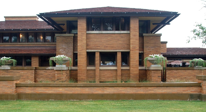
   I made a right turn on Amherst Street, then a right on Summit Avenue to reach the Martin House Complex designed by the great Frank Lloyd Wright. The series of connected buildings, constructed 1903-1905 for the family of businessman Darwin D. Martin, his sister Delta and her husband, are said to be the most important project from Wright’s Prairie School era.


Image result for martin complex frank lloyd wright

   I thoroughly enjoyed the day’s ride, despite the rain break, and realized that, as I made my way past the entrance of the Buffalo Zoo in the northeast corner of Delaware Park, that the worst hill I encountered the whole way was the spiral bike/pedestrian bridge that carried the park trail over the busy Scajaquada Expressway! An additional plus was that, except for the local neighborhood streets, nearly the complete route was in a designated bike lane or on a pathway completely separated from traffic.

   Sue and I enjoyed our last vacation evening at a completely gluten-free restaurant outside of Lockport, and I collected some pastries and baked goods for the ride home the next day. We changed things up a bit from the usual New York Southern Tier drive along Interstates 86 and 81 to the PA Turnpike, and opted for the developing I-99/U.S. 15 corridor through upper-central Pennsylvania. The mountains around Tioga State Forest were beautiful, and the lighter traffic (but really not much slower) on the state highways in anthracite coal country made for a comparatively relaxing return home.     


Monday, August 12, 2019

Ontario, Canada and Michigan's Upper Peninsula - Part Six

   Canada’s Civic Holiday made our drive to Buffalo a bit longer than we had hoped, as the Toronto highways were crammed with lake-goers returning from the long weekend. We were looking at around an eight-hour drive, which stretched to over ten. We knew what we were up against and took a more local route around Canada’s largest metropolitan area, as we would much rather deal with 45 mph speed limits and the occasional traffic light than stutter along for hours, bumper-to-bumper on a highway!

   The Airbnb apartment we booked was wonderful and in a nice location, just outside the trendy Elmwood Village section of Buffalo. The streets were lined with colorful Victorian homes that looked somewhat similar, but when you took a closer look, varied much with details, building materials and arrangement of the façade.
   There were a few streets, designated as parkways, with wide, grassy and/or tree-lined center medians and large traffic circles with gardens or monuments in the center. The bonus was that these streets also had painted bike lanes.


   In fact, the whole city was very bicycle friendly, with not an abundance of on-road bike lanes, “sharrows” (I hope you are familiar with them by now) and bike racks at all the necessary places. The area also had a great network of trails in place, with many miles of new trails and connectors in development.

   Buffalo has been a city that boomed because of its geographic location but has also suffered from it. With Niagara Falls creating a natural obstacle for ships wishing to access eastern or international ports, Buffalo became a perfect spot for transloading from large lake ships to barges for the Erie and (then much smaller) Welland Canals, and also to railroads.
   Once known as the “Breadbasket of the World”, Buffalo had a lakeshore and river lined with concrete silos for the storage of grains (a few others stored cement, just to be accurate). Paddling a kayak through the area would feel similar to driving down a city alley lined with skyscrapers.


   Niagara Falls was the location of the world’s first hydroelectric power plant, built by Tesla and Westinghouse in 1895. The plentiful energy supplied by the river not only powered the Buffalo flour mills, it was a huge draw for companies like Union Carbide and Alcoa, which needed large amounts of power for their manufacturing processes.
   The city was at a prime location for Lackawanna (later Bethlehem) and Republic Steel, as it was convenient to the iron ore reserves in Michigan’s Upper Peninsula, as well as the bituminous coal fields in Pennsylvania. Something that should not be overlooked was Buffalo’s role as a railroad hub, not only for freight, but for passengers, as it was not only a destination for Niagara visitors, but also an important station for connecting trains bound for the Midwest and an entry point for international routes.

The Delaware Lackawanna & Western Station, as it appeared in its heyday

   It was incredible to read that, at the time of the 1950 United States Census, Buffalo was the 15th largest city in the country (at 580,000), the nation's largest inland port (twelfth overall), second biggest rail center, sixth largest steel producer, and eighth largest manufacturer. The city has lost 57% of its population since that time!
   The collapse of heavy industry in the U.S. was a major reason for Buffalo’s steep decline, but a larger factor was the completion of the St. Lawrence Seaway with the building of the deep-water Welland Canal in 1959, which allowed large ocean-going ships to bypass Buffalo completely. Automobile and airline use had put an end to long distance passenger trains by the 1960s, and the eastern freight railroad scene imploded shortly after with the development of interstate highways and increases in truck shipments.
   Improvements to electricity transmission made proximity to Niagara irrelevant for companies. Buffalo winters also cannot be overlooked as a factor in its decline, as it is the country’s snowiest city with a population of more than 250,000. January temperatures have been one of the best predictors of urban success, with cold climates losing significantly. Buffalo isn’t just cold - blizzards will regularly shut down the city completely!

   We had last been to the area over fifteen years ago, and it was obvious the city had long been in decline. There wasn’t a whole lot to talk about or do in Buffalo, other than attend a sporting event, as it seemed only a brief stopover for most folks on the way into Canada or up to Niagara Falls.
   However, since 2009 there has been a concerted effort to develop the harbor with entertainment and arts centers. Some of the dormant mills have been repurposed and the huge deep-water port areas that are protected from Lake Erie by the South Harbor Breakwater system have become a perfect location for the use of kayaks and small sailboats.


   The northern portion of Outer Harbor, once a grain transload site, has become Times Beach Nature Preserve, and the Tifft Nature Preserve sits on land that was once occupied by the Lehigh Valley Railroad’s coal and iron ore docks, and later a municipal waste dump. This incredibly-transformed land is all connected by the Shoreline Trail, which we checked out on Tuesday morning.
   We started north from our apartment and turned west to reach Unity Island which has a 1.65-mile pier extending out its south end to protect the Black Rock Canal running alongside the fiercely-flowing Niagara River. Unfortunately, ice jams on the river damaged portions of the hand rails last winter, and much of the walkway was closed to pedestrians.
   We headed back over the island bridge and rode south on Niagara Street a short distance. The road-separated section of the Shoreline Trail started just as we passed under the Peace Bridge to Canada. We pedaled past the Buffalo Yacht Club and LaSalle Park before the trail weaved through a series of lakeside condo complexes and a few high rise apartments.
   After a short zigzag on Erie Street and Marine Drive, we arrived at the Naval and Military Park, which includes fighter planes, tanks and a helicopter among its collection. Most impressive to us were the destroyer, cruiser and submarine at the park’s docks.


   Just across a pedestrian bridge is the location of the 1825 terminus of the Erie Canal, where many interpretive signs and displays give tourists a feel for the importance of this engineering marvel and its role in the growth of the city and the economy of the Great Lakes region. Canalside has become the setting for festivals and outdoor concerts, and the wharf area features a children’s museum and reflecting pools that become skating rinks in the winter.
   We continued around Key Bank Center, home of the NHL’s Sabres and passed the train sheds from the former Delaware, Lackawanna and Western station, torn down in 1979. The structure’s freight house on the lower floor has long been serving as a terminal for Niagara Frontier Transportation Authority light-rail trains (Metro Rail), but preliminary plans are in place to turn the second floor of the building into a space for shops and restaurants.

 
   At River Fest Park, another attractive outdoor entertainment complex, I stopped to photograph a couple of the immense grain silos, in a semi-panoramic view.


   One of the nearby lift bridges was just letting a large pleasure craft through, and we waited for it to lower before we crossed the Buffalo River and followed Ohio Street and Route 5 past the Tifft Nature Preserve. We took a little detour from the Shoreline Trail here and pedaled east on Tifft Street into the South Park section of the city.
   After doing a loop around the Buffalo and Erie County Botanical Gardens, we made our way west on Ridge Road through the city of Lackawanna. Years ago we had stood with our sons here on an old truss bridge that crossed the multiple tracks below and watched trains moving below. We barely recognized the area today, as a modern steel and concrete span had since been constructed over the railroads.
   Shortly after ducking under Route 5, we were back on a very new section of the Shoreline Trail along Fuhrmann Boulevard. This was once the site of Lackawanna Steel, but most of the buildings have been razed. We crossed the Union Canal and were surprised to see some folks scuba diving in the deep channel.
   We were entering the redeveloped Outer Harbor area described earlier, and after cycling about three miles, past beautiful parks and marinas on Erie’s lakefront, we reached the Queen City Bike Ferry, which conveniently links back to Canalside.


Image result for queen city bike ferry

   The $1 fee for the 5-minute shortcut across the harbor was well worth it, and Sue and I took to the downtown streets (more on that area next time) for a short distance before making our way back to the apartment.

   I hope I didn’t bore you too much with my Buffalo history lesson, but I found the story of the city’s prosperity, demise and revitalization so interesting and encouraging. Our exploration of the area isn’t complete – one more trip blog entry before heading home to PA!


Thursday, August 8, 2019

Ontario, Canada and Michigan's Upper Peninsula - Part Five

   I was a bit disappointed when I found the lake to be glassy calm Wednesday morning and knew I had blown my choice of days, as far as prime cycling conditions, but this weather would make for some great kayaking! We were heading over to St. Joseph Island, which is one of the largest freshwater islands in the world, sitting at the mouth of St. Marys River near the North Channel of Lake Huron.
   The island is also home to Fort St. Joseph Historic Site, the location of the initial attack in the War of 1812. The fort was not only an important British military outpost, but also a significant spot for trade and commerce in the region. Once the British Empire's most westerly outpost, Fort St. Joseph is operated today by Parks Canada.
   We stopped at the north end of the island in the town of Richards Landing to do some internet catch-up, and then drove to the public boat launch at Gawas Bay. Sue had read it was a good area for wildlife watchers, and although we didn't spot the elusive moose for which she was hoping, we did see some small and large fish, osprey, cormorants and a family of mergansers (I had to do some research for those) during our 3.5-mile circuit.


   Little mental “trips to dreamland” occur when we spot lakeside homes like those in the photos below, many with only boat access – sure, shopping would be inconvenient, as would the bike rides, but I could deal with it somehow.


   The island has a reputation as an ideal cycling destination, as it features rolling hills, forested side roads, picturesque views and friendly services, all along roads that have light traffic. We decided to return the next day to try out Route 538, which circles St. Joseph Island.
   I’m sure you won't be shocked to hear that another fantastic day of cycling weather was on tap – low 80s and dry! We parked at the little library in Richards Landing and started counter-clockwise, with intention that Sue would cut across Hilton Road, which pretty much bisects the island, leaving me to finish the 40-ish-mile loop on my own.
   She certainly picked the right portion of the loop, as it was dominated by flat farmland. A short, sharp incline was near Mariner’s Cove, the site of a very narrow passage of the Great Lakes shipping lane, and a longer climb led up to Gilbertson’s, which is the largest maple syrup producer in Ontario. Near the top, I met another cyclist who had just finished climbing up in the other direction.
   He was straddling his bicycle, taking big gulps from his bottle and said, “You’re making me look bad – looks too easy for you.” I explained that we were from a very hilly area of Pennsylvania, and he replied that he was from Windsor, Ontario, where they have “none of this stuff”. He must have felt doubly bad when Sue came peddling up behind me, and he admitted to having walked a portion of the climb.
   The road made a sharp left and after a brief downhill, Sue split off onto Hilton Road, and I faced the (unexpected) rest of the climb. I had the mistaken impression this would be a relatively flat piece of land, but the profile of the route would tell the true story:


   I did enjoy the very long, gradual descent off of that first mountain, speeding along at 25-30 mph for about three miles, but keeping any kind of pace over the successive 50-100-foot climbs that followed was quite a challenge. My friend Mr. Wind showed up when I turned to head along the east side of the island. Sue and I had stopped briefly at Hilton Beach after our kayaking expedition, and I anticipated the tough climb up from the marina, but not how wasted I’d feel by the time I’d reach that spot.
   I also didn’t expect the long drag heading away from Gawas Bay, where we had launched our kayaks the day before – I guess sometimes you just don’t notice it when you are driving in a car! I sure was feeling it now, and despite being nearly out of gas, I received a pleasant break from the wind when I turned toward the southwest along the main route back to Richards Landing.
   My heart sank a bit when I saw a sign stating town was still 6 away, until I remembered this was Canada, and the number would be kilometers, not miles. The remainder of my ride was fairly flat, so it passed quickly, and I was really happy to remember the ice cream spot in Richards Landing and the proportions they tend to serve in the Great White North!

   We had a wonderful Friday of pretty much just sitting around, reading, listening to music and playing some games. On Saturday morning, instead of taking on the gnarly, steep path that led to/from our cabin, Sue and I decided to save our legs and drive out into town and park there. A farmer’s market is held at the Desbarats hockey rink during the weekend, so it was a bit busy there, but nowhere near enough that there was a problem at all finding a space for the van!
   Sue wanted to take a relatively short ride and check out some of the area west and south of town, while I intended to try the around-the-lake route again, since the conditions were a bit calmer. The light breeze that was coming more from the north this day was only in my face on the leg of the route that was mostly a gradual downhill, so it wasn’t much of a factor.
   Some clouds rolled in and gusts picked up in the afternoon, but by that time I was moving in a direction where I wasn’t being affected adversely by the wind. It seems rare, no matter where I am, that I happen to have a tailwind on the return portion of a ride, but this was the case, and the last couple miles were an absolute blast, flying through the flat farmland back to the van. It was a little humorous pulling into the parking lot to find Sue sprawled out in the back of the van (empty without the bikes inside), with the side doors wide open to let in the refreshing breeze.

   Sunday was another scheduled day for loafing/lounging before we would head back over the border to spend a few days in Buffalo.