I few weeks ago my mother was speaking to a few of her close friends,
two of whom live a good distance away and were recovering from fairly serious
surgeries. Because she hadn’t seen them in a while and the COVID situation was
finally improving, Mom asked if maybe I would be interested in handling a portion of the travel by car, since the prospective trip could include stops along the way to visit friends and relatives that I hadn’t seen for years.
The turnaround point for me would essentially be Wilmington International Airport, where my mom would then be taking a flight onto Fort Myers,
Florida. Considering the idea of summer weather in the South, I thought maybe
October would be a good idea, but it also occurred to me that our hosts might
have more freedom to their respective work schedules at this time of the year.
Our plan came together to head down to the Raleigh area for a July 4th
holiday weekend with close friends, the Cookes/Murrays, many of whom I’ve known
since I was born! We would then swing down to Wilmington for a stay with my
aunt and uncle – the last time I had seen them in person was during the Georgia visit with my father back in 2017.
After four years at the University Maryland, I learned to severely
dislike driving anywhere near the corridor between/around Baltimore and
Washington, D.C. Thirty years later, I completely HATE driving through that
area, and I’m not sure why I get suckered into thinking, “Maybe this once, things will be different,” before my hopes all inevitably come crashing down. The
way-too-optimistic estimate on GoogleMaps of 7½ hours instead became a consistent battle with stop-start traffic (most likely early holiday-type volume) for TEN and a half hours!
We kept a pretty good attitude along the way, despite the frustration
and my mother’s back discomfort while sitting in my car’s cushy bucket seats.
We took a couple breaks to pull over and straighten up, stretch and/or take a
short walk, since the traffic was crawling along, and we certainly weren’t
losing any significant places in the miles and miles of lined-up cars!
The hugs, kisses, sharing of stories and laughter shared among the old
gang more than made up for the long trip, and the weather was abnormally cool
during our stay in the N.C. capital area. I had the opportunity to slip out in
the morning for some cycling and was immediately surprised by the constant
consideration by drivers that I witnessed along my route.
The greater Raleigh region has plenty of smaller connecting roads, but I
found it rather dominated by four-lane undivided highways, some of which don’t
have much of a shoulder. If there is some room between asphalt and curb, it is
in the shape of uneven concrete rain gutter – not really safe or comfortable
for narrow-tired racing bikes! It turned out that didn’t really matter because the drivers would, more often than not, move completely over to pass in the left-hand lane!
I kept thinking of instances in Pennsylvania when I’d be nearly snagged on
the sideview mirror of passing cars, and I would gesture with my arms or shout at the driver to leave a little room. I can only recall one instance during my N.C. riding that someone felt a bit too close, and that was when an oncoming driver was making a left, and I was making a right, and we were squeezed into the same lane, but it wasn’t unlike anything I face every day cycling in PA!
I really enjoyed a short spin down Carpenter Pond Road, which reminded me of some of the rural roads near home, as far as being devoid of traffic, but at one segment it had a very tall hedgerow that stirred up memories of driving in the U.K. A local cycling club of a dozen or so buzzed by in the opposite direction to add to the flavor.
I retraced some of the route I pedaled during my last visit to the Tar Heel State, though I was misdirected by some construction approaching downtown Durham and had to ask a policeman to confirm that I was heading in the correct direction. I mentioned that I wasn't from the area, showed him my cue sheet and he suggested a safer route, which I greatly appreciated.
I was once again hitting the American Tobacco Trail, and I even took a bit of self-guided tour of the Durham Bulls stadium this time around. There was a minor glitch during my ride, where the maintenance crew was realigning the A.T.T. in order to shift some of the crossings away from the busy intersections. Most of the crossings up to that point had either a sign or marking on the path itself to alert riders to which road they were intersecting. I was looking for Cornwallis Road and sensed that I had gone too far. I asked a gentleman if he was very familiar with the trail and if I had indeed missed my exit.
“Oh yeah – it was back a couple miles,” he helpfully replied. I had a good idea where I may have made my error, and headed back to find that the street sign had been partially buried in a ditch just a few feet from the intersection. I could just make out the ...A-L-L-I-S on the sign sticking up out of the dirt.
Cornwallis Road led me into the heart of the ResearchTriangle, where
the excellent, sweeping four-lane streets were nearly empty, which I’m sure
would not normally be the case in the early morning! I made my way around Lake
Crabtree, where I enjoyed the shady Hatcher Creek Greenway. A fantastic
boardwalk bridge led me to a link with the Black Creek Greenway.

The trail was gradually rolling downhill, so I knew that I was going to eventually pay for this with some climbing. My prediction would come true almost immediately as I turned east onto roads heading up to North Carolina State University’s campus. A series of short, steep climbs proved to be like a giant, leg-sapping staircase as I rode past the Wolfpack’s Carter Finley Stadium and the state fairgrounds.
I eventually made a connection with the
Reedy Creek Trail and did a quick out-and-back across the impressive bridge
over Interstate 440.

Turning north on the House Creek Trail, I zigzagged through the woods and made a couple more steep descents/ascents before looping up to street level near Glen Eden Pilot Park. I knew that I was nearing the homestretch of my return to the Cookes’ home, and was hoping for a flat course, if not a slight, gradual climb to the finish, but I was totally wrong.
On Duraleigh Avenue, I plunged down a long hill to cross Crabtree Creek and knew this wasn’t a good sign. Sure enough, the matching hill up out of the gorge met me right in the face, and I slogged my way up. Essentially, I had to parallel U.S. Route 70, but I had no desire to ride on that busy street, so I weaved through area communities, some of which were really attractive.
I received the news that, during the first
half of the ride, I had descended far more than I had thought when I reached
one more nasty segment of climbing on Grove Barton and Pinecrest Roads. Indeed,
when I later mentioned those street names to my hosts, they just shook their
heads.
The ride around my aunt and uncle’s neighborhood in the Wilmington suburb of Leland, proved to be less eventful, if only because the scenery is not unlike that I experience when riding inland from Stone Harbor. There were plenty of marshes, scrubby pinelands and ghost forests along the River Road that followed the south bank of the Cape Fear River.
Deep into Brunswick County, I turned north
towards Boiling Springs Lake, with the intention of crossing the dam at
Patricia Lake - apparently, they call it “The Big Lake” around here. Little did
I know, the dam had been blown out by Hurricane Florence in September of 2018, and
the lake drained - thanks GoogleMaps!
A gentleman and his wife were out on a walk,
and he gave me excellent directions to get around the “lake”. I kept feeling
sorry for the people there with homes which no longer have a beautiful
waterside view, but I guess it’s better than having a home that is under water!
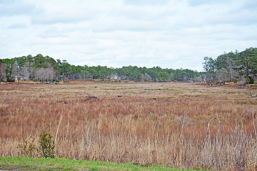
Some areas aren’t awful, sort of looking like a prairie grassland, but the
occasional sight of docks and boat launches suspended in the air was very
strange.
 |
| A shot of the lake shortly after the dam break |
 |
| A more recent view |
The detour didn’t add much to my planned
45-mile loop, and I was glad that, prior to heading out, I made myself very
familiar with the MapMyRide route I had plotted. I saw a street name that I
recognized and cut back across to meet up with the roads included on the cue
sheet that I had clipped to my bicycle stem. The humidity was noticeably worse
that morning, and the temperature was only going to climb higher, so extending
my loop’s distance and possibly running low on water wouldn't have been a great prospect!